Van Long welcomes you!
Contact us
Back
Information about the Vân Long Wetland Nature Reserve.
With its unique, picturesque natural beauty, Vân Long is often likened to "Ha Long Bay without waves."
According to the local people's interpretation, the name "Vân" means cloud and "Long" means dragon. Therefore, Vân Long is a place where dragons and clouds converge, which also signifies a place where water gathers.
1. Overview
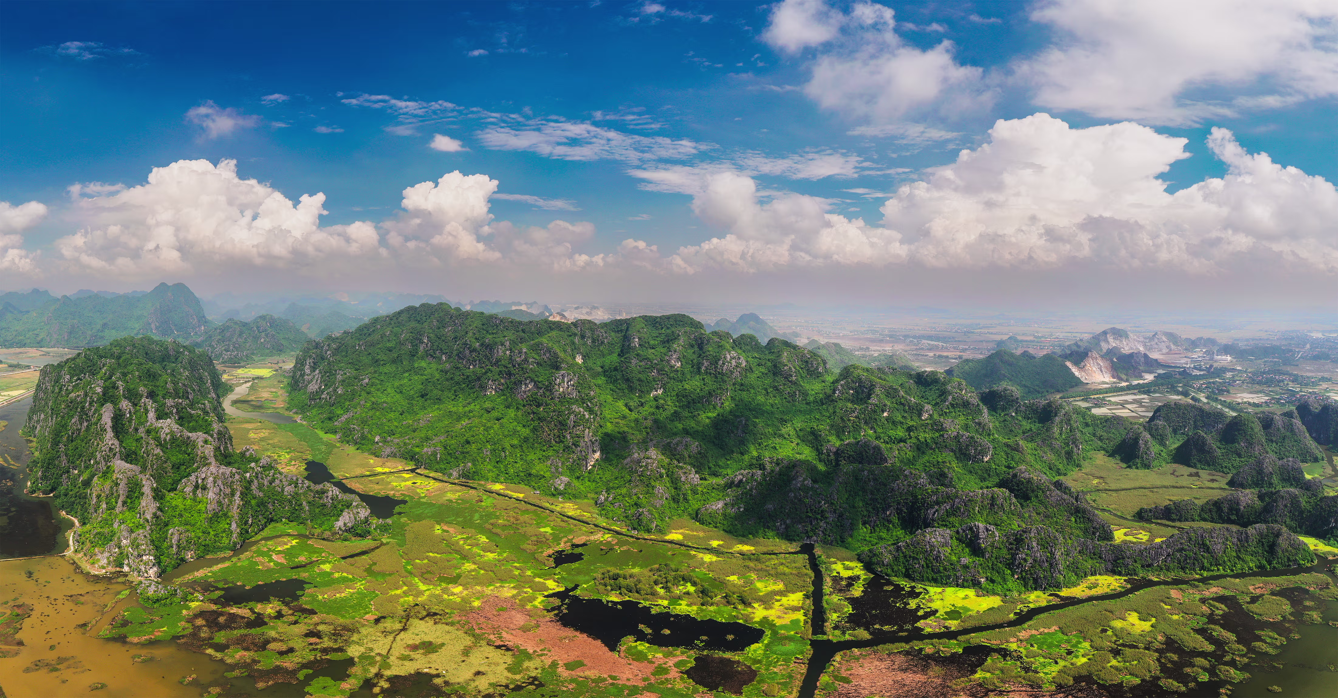
The Vân Long Wetland Nature Reserve (VLWNR), located in the northern part of Gia Viễn district, Ninh Bình province, just 82 km from Hanoi, was established by Decision No. 2888/QĐ-UB of the Ninh Bình Provincial People's Committee on December 18, 2001. It spans seven communes of Gia Viễn district: Gia Hưng, Gia Hòa, Gia Vân, Gia Lập, Gia Tân, Gia Thanh, and Liên Sơn. The reserve features an exceptionally unique ecosystem, with three-quarters of its area being limestone mountains and one-quarter being wetlands.
Notably, it is a habitat for the critically endangered and rare primate, the Delacour's Langur (Trachypithecus delacouri), one of Vietnam's four endemic primate species and one of the 25 most critically endangered primates globally. In 2010, Vân Long was proudly recognized by the Vietnam Record Book Center for having "the largest population of Delacour's Langurs." Today, it has become the best and easiest place in Vietnam for visitors to observe this species. According to research by scientists in May 2018, the population was recorded at over 150 individuals across 19 troops, and current observations by the Reserve's Management Board and local residents estimate the population has grown to nearly 300 individuals. Vân Long also holds a record for having the "Largest Natural Rock Painting" on Mèo Cào Mountain.
In late 2018, VLWNR was recognized as the 2,360th Ramsar Site in the world and the 9th in Vietnam. Its characteristics—a freshwater lake, marshes, and wetlands surrounding limestone mountains, along with a system of underground hydrology—have created the largest inland wetland ecosystem in Northern Vietnam.
This is also an ideal habitat and breeding ground for various aquatic flora and fauna, and a refuge for native and migratory waterbirds. Furthermore, this wetland provides crucial ecosystem services to the surrounding buffer and core zone communities, including resources for fisheries and agriculture, water regulation for irrigation, and a magnificent landscape for recreation and ecotourism development.
With its unique, picturesque natural beauty, Vân Long is often compared to "Ha Long Bay without waves." According to local interpretation, the name "Vân" means cloud and "Long" means dragon. Therefore, Vân Long is a place where dragons and clouds converge, which also signifies a place where water gathers. This name embodies the local people's wish for a peaceful life and favorable weather. Thanks to its unique and majestic natural landscape and the community's efforts to preserve its precious natural resources, the Vân Long Wetland Nature Reserve was officially approved and certified on the IUCN Green List on September 18, 2020. This made Vân Long the first Nature Reserve in Vietnam and Southeast Asia to receive the IUCN Green List certification. This recognition will provide further motivation for the Reserve's Management Board and stakeholders to strengthen biodiversity conservation, especially for the Delacour's Langur population, thereby promoting the sustainable development of the largest inland wetland and limestone mountain ecosystem in Vietnam, and serving as a positive catalyst for sustainable tourism development at VLWNR and Ninh Bình province as a whole.
Despite its modest size of 2,736 hectares, with wetlands accounting for up to 400 hectares, Vân Long contains a high level of biodiversity, with many rare species of fauna and flora listed in the Vietnam Red Book, especially the Delacour's Langur, a species endemic to Vietnam. Located in a region with a long-standing cultural history, it is home to famous historical sites such as: Thung Lau Temple in Gia Hưng commune, where Đinh Bộ Lĩnh trained his troops before unifying the country; Thung Lá Temple, also in Gia Hưng, which worships the mother of Emperor Đinh Tiên Hoàng; the Tu vi Hong nuong’s Temple in Gia Vân commune, which worships the four female generals of the Trưng Sisters; and Thanh Sơn Pagoda, located in a rock cave at an altitude of 30 meters in Gia Vân, which has a path leading to the "sky" and an underground tunnel to Dam Cút. In addition, near the Vân Long Nature Reserve is Địch Lộng Cave in Gia Thanh commune, which is honored as the "Second Most Beautiful Cave of the Southern Sky." (Mai Đình Yên, 2010). Therefore, this area has long been an ideal destination for tourism, research, and study for domestic and international visitors, scientists, and students. (Source: biodiversity reports from the VLWNR Management Board; the book: Vân Long Wetland Nature Reserve; the book: Diversity of Bird Species in VLWNR - published in 2023; updated information on endemic primates in Vietnam from the Endangered Primate Conservation Programme - Cuc Phuong National Park)
2. Geographical Location
Vân Long – The Largest Inland Wetland in Northern Vietnam
The Vân Long Wetland Nature Reserve (VLWNR) is located in the northeastern part of Ninh Bình province, within the territory of seven communes in Gia Viễn district: Gia Hưng, Liên Sơn, Gia Hòa, Gia Lập, Gia Tân, Gia Thanh, and Gia Vân. It is the largest inland wetland area in the Northern Delta region, playing a particularly important role in the conservation of biodiversity and endemic ecosystems.
With a current planning area of 2,484.3 hectares, including 2,016 hectares of special-use forest and 425.5 hectares of dedicated wetlands, Vân Long is managed by the Hoa Lư – Vân Long Special-use Forest Management Board. The area's geographical coordinates are from 20°20’55’’ to 20°25’45’’ North latitude and 105°48’20’’ to 105°54’30’’ East longitude.
Geographical Boundaries:
North: Borders Lạc Thủy district (Hòa Bình province)
South: Borders Dam Cút, extending from Mai Phương hamlet (Gia Hưng) to Đồi Sỏi (Gia Thanh)
East: Borders Gia Hòa commune (Ninh Bình) and Đồng Tâm commune (Hòa Bình)
West: Limited by Coi Mountain (on the left bank of the Bôi River, Gia Hưng commune)
Functional Structure of the Reserve
The reserve is divided into three main functional zones, each with a specific purpose to ensure effective conservation, restoration, and sustainable development:
Strict Protection Zone (1,270.6 ha): Accounting for 46.4% of the total area, this zone is concentrated in Gia Vân, Gia Hòa, Liên Sơn, and a part of Gia Thanh communes. Natural forest makes up 99.6% of this area, reflecting a high level of pristine habitat preservation.
Ecological Restoration Zone (1,463.4 ha): Located in Gia Hưng, Gia Lập, Gia Tân, and a part of Gia Thanh communes, this zone plays a crucial role in biological regeneration. It includes natural forest (50.5%), planted forest (6.9%), and other land (agriculture, water bodies) accounting for 42.4%.
Service and Administration Zone (2 ha): This area houses the Management Board's headquarters (in Tập Ninh hamlet, Gia Vân commune) and facilities for scientific research, ecotourism, environmental education, and other legally permitted investment activities.
3. Terrain
Vân Long Wetland Nature Reserve: A Harmony of Mountains and Waterways
Vân Long possesses a unique terrain where majestic limestone mountains stand out against a vast wetland, creating a landscape similar to "Ha Long Bay without waves." A large portion of the reserve—nearly three-quarters of its area—consists of massive limestone mountain ranges that extend in a northwest-southeast direction from Hòa Bình through Lạc Thủy to Gia Viễn. These mountains have an average elevation below 300 meters, with few peaks exceeding 500 meters. The terrain is characterized by steep slopes, pointed "cat-ear" peaks, and scattered rockfall deposits. Notable peaks include Núi Súm (233 m), Mèo Cào Peak (308 m), and Ba Chon Peak (426 m) (Vũ Tự Lập, 2011).
The wetland portion of the reserve is relatively flat, with an elevation difference of only about 0.5 meters over several kilometers. During the rainy season, water levels rise, transforming the area into a vast sea with mountains emerging like islands. Small U-shaped basin valleys of less than 10 hectares, such as Thung Tranh, Thung Mâm Xôi, and Thung Đầm Bái, form a rare and distinctive landscape. The boundary between the mountains and the wetland also features low schist hills, no higher than 50 meters, which contribute to the rich structural diversity of the terrain (Vũ Trung Tạng et al., 2024).
4. Geology and Soil
Vân Long Wetland Nature Reserve: A Unique Combination of Ancient Limestone and Nutrient-Rich Wetlands
The Vân Long Wetland Nature Reserve features a unique geological and soil composition, shaped by the interaction of an ancient limestone formation and younger wetland areas.
Geologically, the area comprises two main structures. The first is the limestone mountain region from the Triassic-era Đồng Giao Formation, widely distributed in the northern and eastern parts of the reserve, accounting for about 67.5% of the total area. This is the primary geological foundation that forms the system of steep mountains and typical karst topography. The second structure is the low-lying, swampy, and wetland areas formed from Quaternary sediments, where the ongoing process of accumulating fine materials like mud and clay creates favorable conditions for the development of the wetland ecosystem (based on field survey results from geologists in 2011).
In terms of soil, the reserve has a diverse soil system that reflects the variations in terrain and hydrological conditions. It includes:
Feralite soil on limestone (Fv): This soil is reddish-brown or yellow, with a medium mechanical composition and decent quality, but is prone to water scarcity. It is concentrated in the northern and northeastern parts of the reserve.
Feralite soil on sandstone (Fq): This soil is light yellow, has a thin layer, poor structure, and is easily eroded. It is distributed in the Vườn Thị, Đồi Ngô, and Gọng Vó areas.
Alluvial soil (P): Covering about 8.9% of the area, this soil is nutrient-rich and loose, suitable for riparian vegetation. It is distributed along the Đá Bàn and Ngọc Lâm streams.
Mucky soil (J): This soil accounts for about 21.5% of the area. It is rich in organic matter, contains a high percentage of clay (>60%), and undergoes strong anaerobic processes that create a characteristic gray-blue gley layer. It is concentrated in the Đầm Cút, Gia Vân, and Gia Hòa wetland areas.
This geological and soil diversity not only creates Vân Long's distinctive landscape but also plays a vital role in maintaining its unique ecosystem and supporting the habitat for many rare species of flora and fauna.
5. Climate
Vân Long Wetland Nature Reserve: Monsoons Shape the Habitat
Located in the southwest of the Red River Delta, the Vân Long Wetland Nature Reserve is clearly influenced by a tropical monsoon climate, with a distinct seasonal division: hot and humid in summer, and cold and dry in winter (VLWNR Management Board, 2024; Nguyễn Lân Hồng Sơn, 2023).
The average annual temperature ranges from 23.3–23.4°C, with an average humidity of 84–85%. The cold season arrives early, from late November to early March, with about 50–60 cold days, primarily influenced by the northeast monsoon. This period typically has low humidity, ranging from 10–20%, and although temperatures are mostly above 10°C, there are periods of intense cold with temperatures dropping below 10°C. The average annual rainfall is 1,800–1,900 mm, with 88–90% of the rain concentrated in the wet season (April to November) under the influence of the southwest monsoon. The annual evaporation rate does not exceed 1,000 mm but reaches its highest levels during the dry months. These climatic conditions not only affect the regional hydrology but also shape the habitat structure, which is particularly important for the endemic and rare species residing in the Vân Long wetland.
6. Hydrology
Vân Long Wetland Nature Reserve: Where Rivers and Floods Converge
The hydrological regime at the Vân Long Wetland Nature Reserve is directly influenced by seasonal rainfall, with the river system playing a decisive role in regulating water levels and shaping the aquatic environment (Vũ Trung Tạng et al., 2004).
The area is located within the basin of the Đáy River—a major tributary of the Red River—which ultimately flows into the sea through the Đáy estuary. The Hoàng Long River, a significant tributary of the Đáy, flows from the confluence of the Bôi and Lạng rivers at Kênh Gà to Gián Khẩu bridge. The water source for these rivers originates from the limestone mountains of Hòa Bình province, with the Bôi River being the largest. A distinctive feature of the area is the abrupt transition from mountainous terrain to the low-lying delta, with no transitional buffer zone. This causes floodwaters to flow quickly and strongly during the rainy season, significantly impacting water levels and the depth of flooding in the reserve's core area. Additionally, the region has small streams like Lạng and Canh that maintain a year-round flow, albeit at a low volume, even during the dry season. This hydrological system is crucial not only for sustaining the vast wetland of Vân Long but also for forming and preserving the unique habitat of many rare species.
Discover, preserve, feel & accompany Van Long


© Copyright Van Long
2025. All rights reserved.
Many thanks to the photographers: Grégoire Dugois, Xuân Lâm, Nguyễn Mạnh Hiệp, Đinh Văn Huyên, Lê Khắc Quyết and Trần Văn Bẩy for the beautiful photos.